


walser_25

My Switzerland
Optez pour le retour à la nature GUIDE+
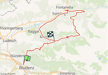

Length
36 km

Max alt
1842 m

Uphill gradient
2644 m
Km-Effort
70 km

Min alt
576 m

Downhill gradient
2191 m
Boucle
No
Creation date :
2014-12-10 00:00:00.0
Updated on :
2014-12-10 00:00:00.0
--
Difficulty : Unknown

FREE GPS app for hiking
 SityTrail
IGN / Geographical institutes
SityTrail Plus
The world is yours!
About
Trail Walking of 36 km to be discovered at Vorarlberg, Bezirk Bludenz, Stadt Bludenz. This trail is proposed by My Switzerland.
Positioning
Country:
Austria
Region :
Vorarlberg
Department/Province :
Bezirk Bludenz
Municipality :
Stadt Bludenz
Location:
Unknown
Start:(Dec)
Start:(UTM)
561718 ; 5222971 (32T) N.
Comments